This is the equivalent of surveying over 9,000 football pitches. I can confirm, though, that Buckden Pike is quite a bit steeper than Elland Road and offers nowhere to get a pint. As part of our work we need to be able to create accurate maps of the sites we survey, recording peatland features we find there and also exactly where we have deployed our survey equipment. This is important given the vast areas we survey and the fact that these areas will be visited many times and not always by the same people. Clear, accurate recording of location data is incredibly important to the efficient operation of our field work and our overall decision making. So how do we achieve this?
An Ode to Geode

Geode Global Navigation Satellite System (GNSS) receiver © Juniper Systems
The 2021/22 report from Yorkshire Peat Partnership identified that in total approximately 6,500 ha of foot surveys have been completed by the team since 2009.

Our comms manager demonstrating the portability of the Juniper Systems’ Geode GNS3 and also his evident comfort with technology © Lyndon Marquis
A relatively new addition to the YPP team is Juniper Systems’ Geode GNS3. The Geode is a Global Navigation Satellite System (GNSS) receiver, which can connect via Bluetooth to any device and provide locational data to a sub-metre level of accuracy. Peat bogs can be an unforgiving environment and the Geode is designed to operate in these harsh conditions, rated IP68 it is dust-proof and waterproof up to 1.4 metres. The suggested -20oC operating temperature limit is something I would hope we don’t test, but you never know in Yorkshire. The device itself weighs just under 400 grams and measures approximately 110x110x57 mm and so thankfully doesn’t make a big impact on our kit-bags. It also provides an actual ‘all-day battery life’, so we can rely on the device for a full day in the field. The main attraction, however, is its accuracy.
Your mobile phone likely uses the Global Positioning System (GPS) to get a location for its various services; this is run off a network of 31 navigational satellites owned by the US Government. From this you might return a location within 2-5 metres of your actual position. GPS is one of many similar navigational satellite networks, other examples being GLONASS (Russia), GALILEO (EU) and BeiDou (China).
The Geode however uses GNSS. A GNSS system can receive positioning data from multiple different satellite networks. This greatly increases the amount of locational data available to it, and also its accuracy, over using GPS alone.. The following two diagrams illustrate this where we see the amount of satellite coverage to a GPS device and a GNSS device in the same location.
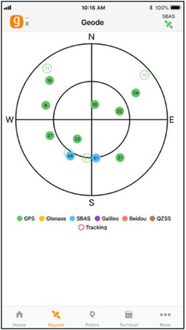
Satellites available to a non-GNSS system © Juniper Systems
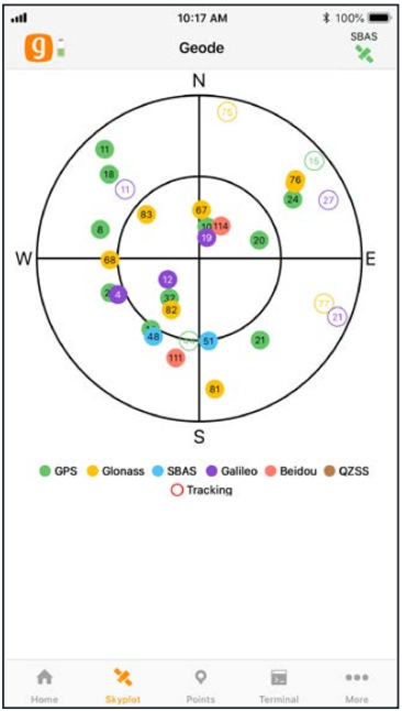
Satellites available to a GNSS system © Juniper Systems
What this means in the field is that when we log a location using a Geode we can be very certain of being able to find it again, even if the feature is very small. This is particularly the case when dealing with our survey equipment. Let’s look at the deployment of a peat depth rod as an example.
A peat depth rod is a metal rod inserted into the peat and used for measuring its depth. All that remains visible above ground is a short length of metal bar with a 4cm washer at the end of it.

Peat depth rod © Josh Burge
Over time this can easily go missing amongst the vegetation and peat. This is where our Geode comes in! When the peat depth rod is deployed, we use an Android tablet equipped with mapping software to record the location. The tablet is connected to the Geode via Bluetooth and uses the Geode to establish its location. We can actually see in a field at the bottom of the screen the current level of accuracy the Geode is recording our location at. Below is a screenshot from our mapping software indicating that our given position on the map is within only 12 centimetres of our actual position in the real world!

Geode is only 12 cm distant from our actual physical location © Jamie Wharton